About Our Association

My photo
The Nebraska Floodplain and Stormwater Managers Association (NeFSMA) is an active organization of over 100 members representing over 50 organizations. NeFSMA pursues multiple purposes including: 1.)promote public awareness of floodplain and stormwater management; 2.) promote the professional status of floodplain and stormwater management and secure all benefits resulting there from; 3.) promote cooperation and information exchange between individuals and entities concerned with floodplain and stormwater management; 4.) keep individuals concerned with floodplain and stormwater management well informed through educational and professional seminars and to provide a method for dissemination of information, both general and technical; 5.) inform and educate concerned individuals of pending floodplain or stormwater legislation, funding and other related management matters. Please browse our website to learn more about NeFSMA at www.nefsma.net. If you are interested in joining, either contact one of the board members or complete the membership form.

Friday, May 27, 2011

Nebraska H2O Coordinates Stream Bioassessment Workshop

On May 18-19, the 10 member communities of Nebraska H2O coordinated a stream bioassessment workshop in Grand Island, Nebraska.  There were 15 attendees (MS4s, NRDs, UNL, and USGS) plus the two presenters from the Central Plains Center for BioAssessment at the University of Kansas.  Felsburg Holt & Ullevig arranged and facilitated the workshop.  The purpose of the workshop was to explore new methods to measure effectiveness of Storm Water Management Programs for MS4s. 

The CPCB has a summary and downloadable copies of the presentations available on their website - http://www.cpcb.ku.edu/workshops/html/2011_GrandIsland.htm and the first two videos on the NeFSMA YouTube Channel have been posted with small segments from the field tour portion of the workshop.


The group covered basic information about stream bioassessement concepts, methods, taxonomy, data collection, and reporting.  Half of the first day was held in the field.  The group visited a segment of the Wood River upstream of Grand Island which could be considered the reference condition where urban influences have not impacted the stream.  This is the location seen in the first video.

The group then moved to the sampling location which was near State Fair Park.  After some more introductions about field equipment and filling out the assessment forms (seen in the second video), anyone that wanted to could get into the Wood River and start trying their hand at sampling the stream. 


The workshop was successful and the feedback was great.  Nebraska H2O Communities hope to use stream bioassessment methods for algae, macro-invertebrates, and/or fish to more effectively monitor the impacts of stormwater pollution from their communities.  

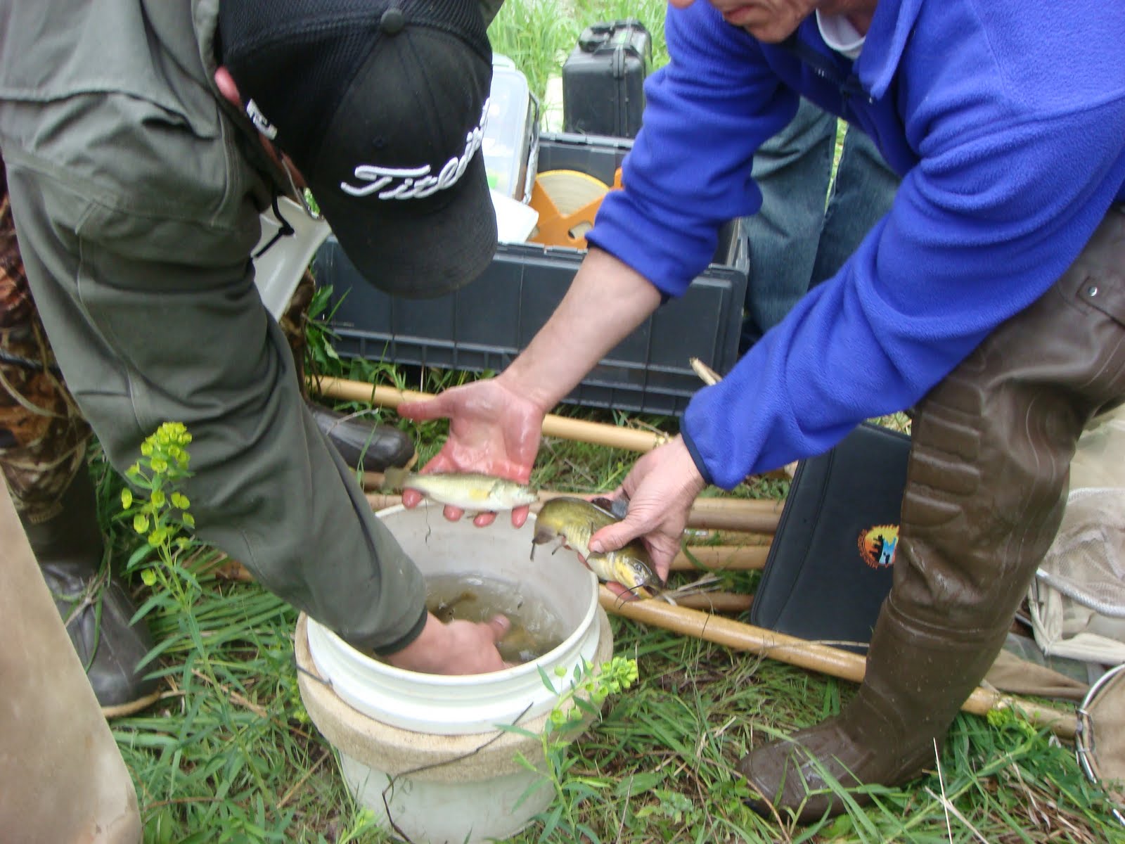
Don't think there are any fish or macroinvertebrates in our urban waters?  Check out these two photos which were taken AFTER the group had tromped around in the stream channel for about an hour. 


 Submitted by
Jesse Poore

Thursday, May 26, 2011

ASFPM Conference - Mike McIntosh

I also attended the ASFPM annual conference in Louisville Kentucky. This was my first conference and as Lori mentioned if you haven’t attended one in the past, I would highly encourage you to attend next year’s conference in San Antonio. As a new attendee, the conference was a great education on the structure of ASFPM and how things are actually getting done in the trenches. It was exciting to learn how easy it is to get involved in the different committees. There were over three hundred papers submitted with only about a third of them presented. As evident by this, the presentations were high quality, interesting and timely. Approximately 1,000 people attended the conference, so there were ample opportunities to network with people from different communities. With my involvement in the Omaha CSO program, I was especially interested in speaking with some of the leaders of the Louisville CSO program.


Of course conferences aren’t all about presentations. ASFPM offered several tours and outside events. I took advantage of the tours to visit Marengo Cave, canoe down the Blue River and tour Churchill Downs. It was interesting to hear how high floodwaters were in the recent past at Churchill Downs. The horses would have been swimming across the finish line if they would have raced that day. The final night of the official conference was spent in Louisville’s new downtown area called “Fourth Street Live”. If you have a chance to visit, make sure to check it out.

The theme of next year’s conference is “Mission Mitigation” in San Antonio, Texas from May 20-25. If you haven’t been to the Riverwalk, it is something you won’t forget. This year Virginia had the most participants with 116. I don’t know if we can beat that, but let’s make sure Nebraska is well represented next year.

Submitted by

Mike McIntosh

Tuesday, May 24, 2011

Omaha Green Infrasturcture Tour

On Friday June 17, the UNL Stormwater Team will be sponsoring a tour of some of Omaha's stormwater Best Management Practices.  This will be a great opportunity to see how people across the city are implementing porous pavements, rain gardens, bioretention gardens, rainwater harvesting systems, and green roofs!

When: Friday June 17, 2011 9:00 am - 3:30pm
Where:The bus leaves from the Douglas/Sarpy Extension Office - 8015 W. Center Road, Omaha
Cost: $15 - Lunch will be provided
Contact Katie Pekarek at (402) 643-2981 or kpekarek2@unl.edu for more information.

Monday, May 23, 2011

Another Great Conference

Last week I had the opportunity to attend the Association of State Floodplain Managers annual conference in Louisville, Kentucky. 

The conference is five days packed full of everything from technical workshops to field tours to policy discussions, as well as presentations from floodplain and stormwater experts from all over the world.

One of the most interesting things about the conference is the presentation of both sides of one issue.  You will find reasons for structural projects as well as reasons for non structural projects.  You will learn why a BMP works for one community yet not for another.

The keynote speaker this year was Jill Techel, Mayor of Napa, California.  She discussed the flood mitigation project that the City of Napa has undertaken.  I’ve been fortunate enough to visit Napa, and I never would have guessed that many of the features of the community had a dual purpose.  The downtown amphitheater is actually a flood storage area.  The architecturally-beautiful bridges replaced bridges that once constricted flow.  Their riverside trail is incorporated with a floodwall.  And they have further plans for enhancements to their park system to allow for flood flows to be diverted away from residential and commercial areas.   It just goes to show that it is possible to incorporate flood mitigation features into a community as an enhancement.

There were several members of NeFSMA who attended the conference and we will get some additional feedback from them posted over the next week.

If you have an opportunity to attend, I hope you take advantage.  This conference has something for everybody including building code officials, insurance agents, engineers, regulators, and anyone who has an interest in water resources.

Submitted by Lori Laster, NeFSMA Treasurer

Thursday, May 19, 2011

Mississippi River Tests the Old River Control Structure - Historical Comparison

How much energy do you imagine is behind Mississippi River flows of 2 million cubic feet per second - sustained for three months?  The Army Corps of Engineers is confident that it is not enough to bring down the Old River Control Structure currently preventing the River from charting a new course down the Atchafalaya River valley (which, by the way, the Mississippi would prefer to do!).  Let's hope they are correct as more than just a river diversion structure is at risk if it does not.  I encourage you to take just a couple minutes to pour over this articulate summary from Weather Underground http://www.wunderground.com/blog/JeffMasters/comment.html?entrynum=1801.

The graphics, history, and description of possible impacts are eye popping.  The graph in the article displayed the (now previous) 1973 record flood event by comparison and is a snapshot taken May 13, 2011.  The most current version will be found at the following link for you to observe http://www.mvn.usace.army.mil/eng/edhd/lat.gif.  At the time of this post, the 1973 event had just been exceeded and was still climbing rapidly.

Source: US Army Corps of Engineers


Tuesday, May 17, 2011

Registration Now Open for 3rd Annual Conference

Registration is now open for NeFSMA's 3rd Annual Conference. 

The conference will be held at Mahoney State Park on June 23, 2011.  Click here for a map.

The cost to attend is $90 for NeFSMA members and $125 for non-members.  Lunch will be provided.

Space is limited to 130 attendees.  Please send the registration form and registration fees to Lori Laster by June 4, 2011.  The registration form and agenda can be found here.

Hope to see you there!

Saturday, May 14, 2011

Mississippi River Flooding

MSNBC.com posted a slide show of photographs taken in areas flooded by the Mississippi River over the last several weeks.  Click here to view the show.

Image #6  shows a satellite comparison of Memphis, Tennessee on April 21, 2010 and May 10, 2011, when the river crested.

Wednesday, May 11, 2011

Flooding Mississippi River - Blowing Up Levees and Returning Floodplains

This morning, the Mississippi River crested in Memphis, rising just shy of the all-time record height of 48.7 feet set during the great 1937 flood. The river, normally half a mile wide at Memphis, is now about three miles wide.  The only reason that this flood didn't set a new record was because the Army Corps of Engineers blasted levees and opened up two "floodways."  Find full articles via GOOD Magazine

Should We Follow the Dutch and Give Land Back to the Flooding Mississippi River?

The Project Flood Is Upon Us": Mississippi River Surge Is a 1-in-500 Year Event


The promotional video for "Room for the River" (english) or "ruimte voor de rivier" (dutch) is worth 3.5 minutes of your time just to see how social marketing for flood-related topics occurs in other parts of the world.  And if you want to see video of the levee being taken down for the Project Flood article from Wall Street Journal "Great Balls of Fire" News Hub.


Tuesday, May 10, 2011

Norfolk Rain Garden Workshop

The University of Nebraska-Lincoln Stormwater Management Team will be hosting a rain garden workshop in Norfolk.  The event will include classroom and hands-on instruction.

When: Friday June 3, 2011 9:00 am - 4:00 pm
Where: UNL Classroom, Lifelong Learning Center, 601 E. Benjamin Ave, Suite 105, Norfolk, NE
Cost: $15 - Lunch will be provided
Contact Wayne Ohnesorg at (402) 370-4040 for more information.

Monday, May 9, 2011

ASFPM Releases Floodplain Management 2010: State and Local Programs Final Report

ASFPM and FEMA Mitigation Division released the 2010 Floodplain Management : State and Local Programs Final Report.  This report is the most comprehensive collection of state and local floodplain management practices.

This report can be useful to local floodplain managers in identifying areas that could be improved in local programs or for those communities just developing a floodplain management program.

ASFPM has created a webpage for the report as well as the database containing survey responses used to support the writing of the report.

The webpage is http://floods.org/index.asp?menuid=730.   The following documents can be found on the webpage:

  • Final Report:  This report entitled Floodplain Management 2010: State and Local Programs – Final Report
  • Appendix:  Full appendix providing detailed tables of survey responses entitled Floodplain Management 2010: State and Local Programs – Appendix
  • Web-Based Mapping Portal:  The web-maps allows you to select a specific survey question and then view and compare how each participating state responded to that question
  • Survey Questions: Printed version of the on-line survey questions
  • Individual State Surveys: Detailed survey responses for a specific state

Thursday, May 5, 2011

Responsible Floodplain Management - Invitation for ASFPM Conference Attendees

I like the invitation below.  I'll tell you why.


I like it for a couple of reasons.  First, the title.  When I read something that has a tag line like "Responsible Floodplain Management" I automatically assume..."hmmm, there must be an irresponsible floodplain management approach" and I'm automatically hooked.  Because, of course, I don't want to be irresponsible.   But, that's just me.

The other reason I like it, is because if you are going to the National ASFPM Conferenect in Louisville, Kentucky you can take advantage of this advance opportuntiy to hear from OUR key note speaker for the NeFSMA Annual Conference.  Terri Turner with Augusta-Richmond County Planning Commission and Co-Chair of the No Adverse Impact (NAI) Committee will be sharing some of the same information at both events.  If  you are going to the National Conference, you should take advantage.  If you are not, be sure to come to our Conference.  You will hear Terri plus over 15 other speakers presenting on important floodplain and stormwater information the you can't live without.  Registration is coming soon.

Wednesday, May 4, 2011

Flood and Osama Bin Laden

When looking at the map on the news of Abbottabad, where Osama Bin Laden was killed, I couldn't help but recall that the town was the near the area of the 2010 Pakistan floods.  It turns our flooding relief efforts may have helped capture OBL.  See the story below:

Flood relief mission led US to tip of OBL
ISLAMABAD: Helping flood hit Pakistanis has paid back in terms of historic achievement as American marines got tip of Osama Bin Laden’s Abbottabad hideout during their flood relief mission last year.
Well-placed sources told Online that some 600 US Marines who participated in flood relief operations last year in the Khyber Pakhtunkhwa actually got a hint about OBL’s presence in the area.
During relief operations, US marines through 35 state of the art helicopters, equipped with secret cameras, had continued monitoring of the area. The US forces had obtained aerial photographs of the entire Khyber Pakhtunkhwa region wherever the possibility of Osama’s presence existed and proofs of his presence were gathered. Through these photographs and evidence US managed to make history.
Sources further told that these US marines also interacted with the locals and obtained information. After the relief operation US obtained major proofs of Osama’s presence in the Khyber Pakhtunkhwa area. US had verified all leads for six months before launching their operation which led to the killing of most wanted terrorist.
During the relief operation the cooperation between Pak Army and US Marines was exemplary